
The Hadejia Valley Project, Phase I is located within Auyo, Kaugama, Miga, Kafin Hausa and Hadejia Local Government Areas of Jigawa State between the Hadejia and Kafin Hausa rivers. The project is designed in such a way that water released from the upstream Challawa and Tiga dams into the river system could be used for irrigation. A barrage/storage pond with a capacity of 11.0 million cubic meters was constructed to store the water and from there the water is diverted through water control structures into the irrigation canals of the project area.
The potential irrigable area of the project is 25,000 hectares divided into two phases for ease of construction, namely HVIP phases I and II, each covering an area of 12,500 hectares. Construction works on the project started with phase I in 1981 with the contract awarded to Messrs BEC Frères with Haskonings Engineering Consultants as the project supervising consultant, which due to budgetary constrains was further subdivided into two stages in 1992, namely phase I stage I (7,013 hectares gross and 6,175 ha net) and phase I stage II (5,500 Hectares gross).
The Hadejia Valley Irrigation Project I is a gravity irrigation scheme, under stage I of the first phase covering 12,500 hectares, 5,300 hectares were developed and operational. The project is made up of a diversion structure, Feeder Canal, North Main Canal, Distributory Canals, Field Channels, roads and drainage systems. The Field Channels feed the farm plots directly. The irrigation area is sub-divided into sectors, each receiving water flow from the main canal through the sector turn-out and distributory canal from where irrigation water is delivered into the tertiary canals. The irrigation system has various water control structures to regulate the flow in the canals, which are easy to operate and maintain to ensure safety. Night Storage Reservoirs have been provided at high grounds within the project area to enhance timely irrigation water supply. The existing structures within the completed irrigation areas include:
- The Head works consist of a barrage 1 km long of earth fill diversion dam, 9.25 meter high across Hadejia river, bounded by a 12 km long south dyke and a 12 km long north dyke. The dykes were completed in 1981 contract.
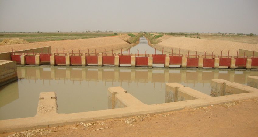
- The Storage pond has a capacity of 11.4 million cubic meters of water. Its level at minimum supply capacity is at elev. 37.46 m. and 38.15 m at maximum supply capacity. Maximum flood level is at elevation 38.25 m. The main structures at the storage pond are: 15 nos. 1.83m x 1.83m off-take gates with a capacity of 30m3/sec; 6 no. 1.83m x 1.83m sluice gates with a maximum discharge capacity of 90m3/sec. for sediment exclusion and 5 no. radial sluice gates with spillway capacity of 150m3/sec.
- The Feeder Canal is a clay lined trapezoidal canal in shape that conveys water from the storage pond to the main canal with base dimension of 19.8 m, water depth of 2.4m and discharge capacity of 30m3/sec. It has a total length of 2.87 km. A side spillway was provided to spill excess water into natural drainage in event of flooding during the operation of the project.
- The Main Canal consists of the South and North main canals with clay lining and trapezoidal in shape. Presently only the North Main Canal is completed, which has a design capacity of15m3/second. To account for future extension, it has been provided with an extra capacity of 3.9m3/second along its length of 27 km. Side spillways were constructed at strategic points to discharge excess water during emergency situation.
- Lateral and distributory canals take off from Sector turn outs, that feeds the field channels and deliver water to farm plots.
Drainage System consists of the main drain, collector drains, field drains and drainage buffer.